
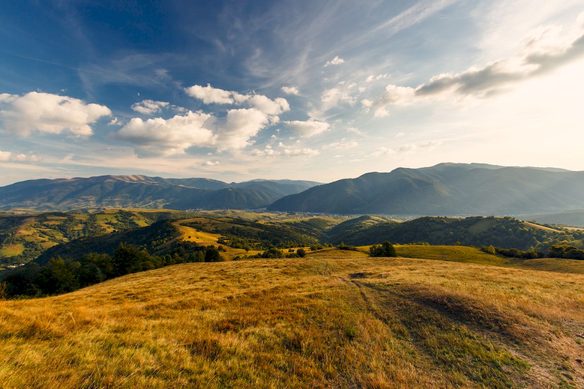
The Carpathians belong to the largest mountain ranges in Europe, they cover an area of about 209 thousand km2. They are about 1,300 km long and stretch between the Danube Gap: near Bratislava on the Slovak-Austrian border and the so-called “Iron Gate” on the Romanian-Serbian border. The geological structures of the Carpathians reach even a bit further. Sometimes, the Eastern Serbian Mountains in Serbia are also included.
These mountains are located in seven European countries. Over half (55.5%) of their area is part of Romania, 17.1% – Slovakia, 10.3% – Ukraine, 9.3% – Poland, and approx. 7.8% – Hungary, the Czech Republic and Austria. Slovakia is considered the most Carpathian country because it covers 73% of the total area of this country (Warszyńska 1995).
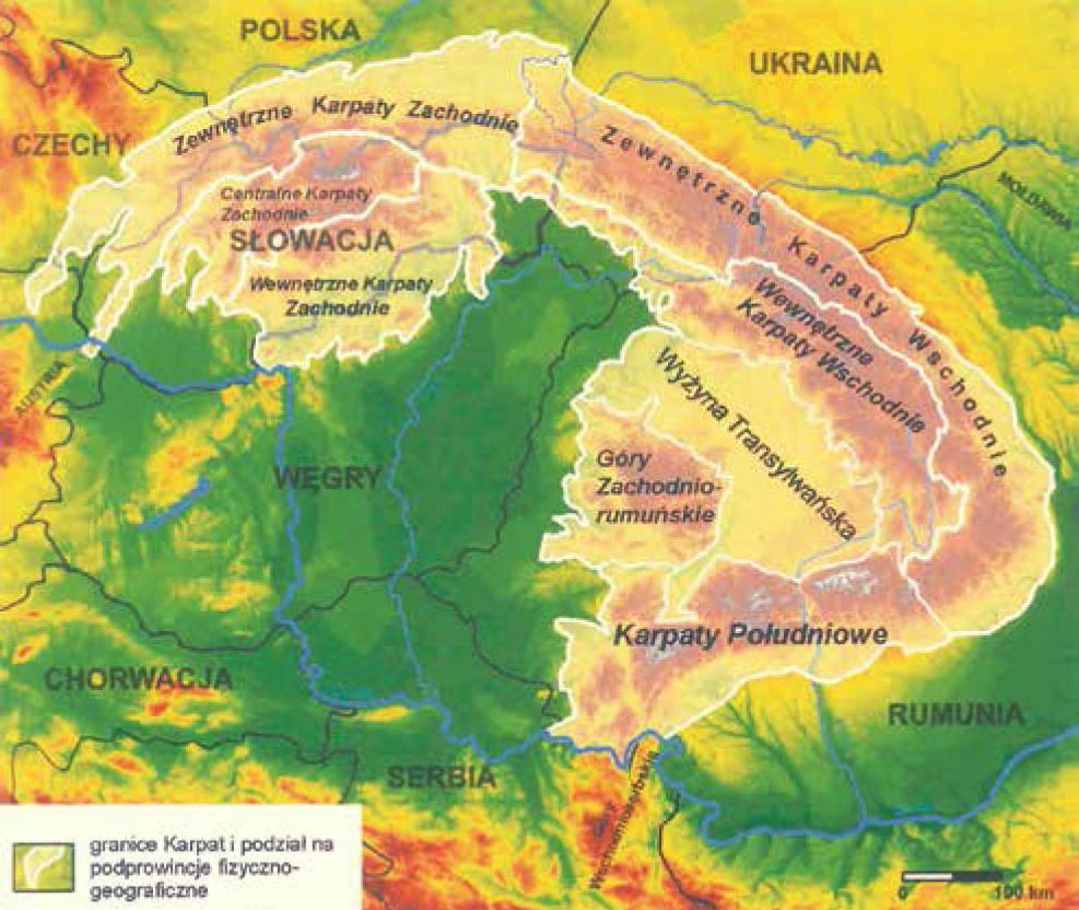
Source: developed by P. Kłapyta based on: J. Kondracki (1978), published in Wantuch M., Kłapyta P., Środulska-Wielgus J. (2016)
They consist of several parts. The Western Carpathians, the Eastern Carpathians and the Southern Carpathians are most often mentioned in the context of the Carpathian arc. However, other classifications can also be found in literature, e.g. into the Western Carpathians and the South-Eastern Carpathians, Kondracki (1978). Such a division was adopted in this study, however, referring to the classification according to Balon and Jodłowski (2014) as well as Czeppe and German.
The division into provinces, subprovinces and macroregions is presented, and in the case of the Outer Western Carpathians and Outer Eastern Carpathians also into physical-geographical mesoregions.
The interior of the Carpathian arc is occupied by a tectonic hollow – the lowland Pannonian Basin. The highest peak in the Carpathians is Gerlach (2655 m above sea level) in the Slovak Tatras, and the lowest mountain pass in the main ridge of the Carpathians is the Dukla Pass (500 m above sea level) in the Low Beskid on the Polish-Slovak border.
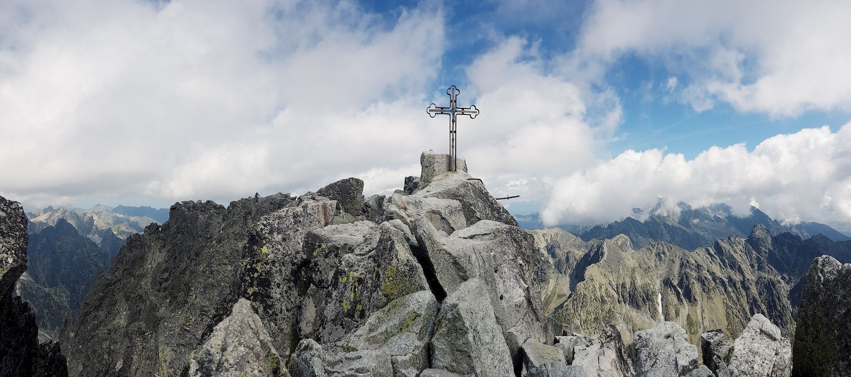
Gerlach – on the left there is a demanding, exposed granite route called Martin’s Road leading from the Polish Ridge to it.
The Western Carpathians include the Outer Western Carpathians, Central Western Carpathians and the Internal Western Carpathians. The South-East Carpathians include the Outer Eastern Carpathians and the Internal Eastern Carpathians as well as the Southern Carpathians, Transylvanian Plateau and West Apuseni Mountains.
The Outer Carpathians are medium mountains. They are built of less resistant flysch formations of Cretaceous and Paleogene period, i.e. sandstones, slates and conglomerates. They have a nappe structure. In the north of the arc there is also a mountain sculpture.
The Outer Western Carpathians include bands belonging to the macro-regions of the Western Beskids, Central Beskids, Western Beskidian Foothills and Central Beskidian Piedmont, as well as the Austrian-Moravian Carpathians, Central Moravian Carpathians and Bielawy.
According to the latest division of the Western Carpathians proposed by Balon and Jodłowski (2014), the Western Beskids include the Silesian and Moravian Beskids, Silesian Beskids, Beskid Mały, Kotlina Żywiecka, Pewelsko-Krzeczowskie Range, Międzygórze Jabłonkowsko-Koniakowskie, Beskid Żywiecko-Kysucki and Beskids Orawski, Orava Departments, Kysuce Mountains and Orava Magura. East of the Beskid Żywiecko-Orawski there are the Middle Beskid (Makowski) and the Beskid Wyspowy, and the Orawsko-Jordanowski and Gorce Foothills located south of them, and further the Beskid Sądecki with the Sadecki Valley and the Popradskie Foothills (that is included by Kondracki in the Beskid Sądecki – Lubovnianska vrchovina) and the Czerchowskie Mountains. The highest in the Western Beskids and the entire Western Outer Carpathians is the massif of Babia Góra (Diablak 1725 m above sea level) in Beskid Żywiecki on the Polish-Slovak border.
Located west of the Kysucké Beskydy and south of the Silesian-Moravian Beskids, Jaworniki, as well as the Myjawskie Foothills, White Carpathians, Hostyńskie Mountains, Wizowickie Mountains and the Vsetyne Mountains already belong to Bielawy. The Central Moravian Carpathians include Ždánice Forest, Chřiby, Kyjov Hills, Litenčice Hills and the Central Moravia Valley.
The Central Beskids include the Low Beskids on the Polish-Slovak border and the Ondavská Highlands and Laboreck Highlands located entirely on the Slovak side.
Pokucko-Bukowińskie Mountains.
The Beskid Mountains are adjacent to the north, separated by a morphological threshold, as well as a flysch belt of the Hills. The Western-Beskidian Foothills include the Upper-Moravian Foothills, Jiczyńskie Foothills, the Silesian Foothills and the Wieliczka Foothills (Wiśnickie Foothills is also sometimes included there). Whereas, the Central Beskidian Piedmont include: Rożnowskie Foothills, Ciężkowickie Foothills, Strzyżowskie Foothills, Dynowskie Foothills, Przemyskie Foothills and Doły Jasielsko-Sanockie. Sometimes they are divided into Gorlice Depression, Jasielsko-Krosno Basin, Jasielskie Foothills and Bukowskie Foothills. The foothills are the northernmost part of the Carpathians. Their boundary is determined by the range of Cretaceous and Paleogene period flysch overlapped by Miocene settlements.
The Central Western Carpathians are built of resistant, Paleozoic crystalline rocks, metamorphic and Mesozoic sedimentary rocks, as well as Cenozoic volcanic rocks (Kondracki 1978). Their characteristic feature are horst. According to Balon and Jodłowski (2014) and others, we include the ranges that are part of the Podhale Depression (also known as the Orava-Podhale Depression or the Orava-Podhale Basin), the Little Carpathian Chain, the Middle Wag Valley, Małofatrzański Chain, Tatra Mountains, Nitrzansko-Turczańskie Depression, the Liptowsko-Spiskie Depression, the Spisko-Szarsyskie Mountains, the Trybcz and the Niżniotatrzański Chain which also included the Great Fatra. The highest peak of the Central Western Carpathians and the whole Carpathians is Gerlach (2655 m above sea level) in the High Tatras.

Western Bieszczady (High Bieszczady) – view from the Wyżna Pass to Połonina Caryńska, Tarnica group in the background.
The Internal Western Carpathians are the least compact part of the entire West Carpathian province. The core are the Ore Mountains built of Palaeozoic and crystalline rocks, sometimes covered with Triassic limestone series, but there are also young volcanic rocks, depressions filled with Palaeogene flysch and Neogene sands, clays and marlstones (Kondracki 1978). According to Balon and Jodłowski (2014), these include the ranges included in the Depression of the Upper Hron (Bruzda Hronu), Western Ore Mountains, Eastern Ore Mountains, Depression of the Ipel-Hornad (Depression of the Ipel-Slana), which also includes the Košice Valley, the Slovak-Hungarian Karst, the Slansk-Tokaj Mountains, and the North-Hungarian Medium Mountains, which also includes Czerhat.
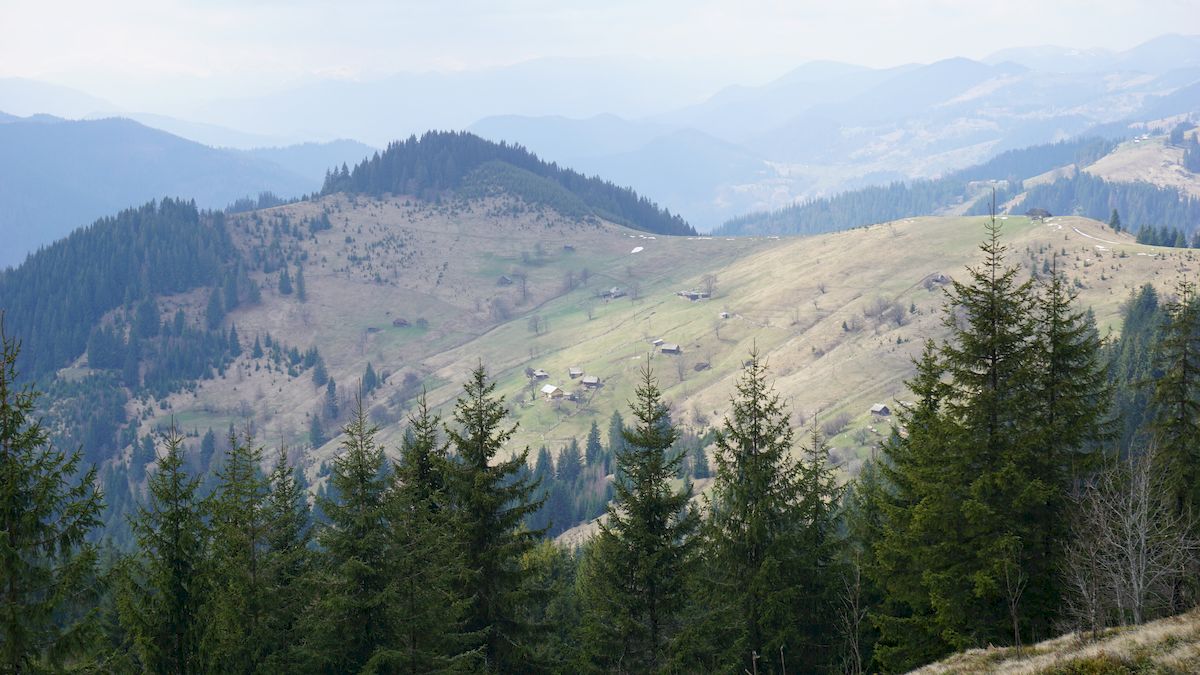
The Outer Eastern Carpathians (Eastern Beskids) are an extension of the Outer Western Carpathians, and are much higher than them. They are characterised by tectonically and lithologically determined grate range system. According to Kondracki (1978) and other geographers, they include the Wooded Eastern Carpathians, Eastern Polonynian Beskids, Moldavian-Muntenian Carpathians and Eastern Subcarpathians. The Wooded Eastern Beskids include the Sanocko-Turczańskie Mountains (Low Bieszczady), Beskidy Brzeżne, Western Bieszczady (High Bieszczady), Eastern Bieszczady (Skolskie Beskids), Gorgany and Beskids (Pokucko-Bukowińskie Mountains). The Eastern Beskids of Połoniny include Połonina Równa, Borżawa, Połonina Czerwona, Świdowiec, Czarnohora and Połoniny Hryniawskie. Hoverla (2061 m above sea level) is the highest peak in the Outer Eastern Carpathians in Czarnohora.
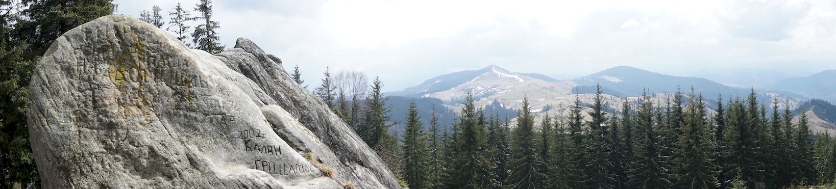
Pokucko-Bukowińskie Mountains in the area of Pisany Kamień. From a distance, it looks like a large rock covered with signs and inscriptions. According to legend, it is a kurgan in which the king was lied in golden armour.
The Moldavian-Muntenian Carpathians include Ridges of Bukovina, Stînișoara, Tarcău, Czukaskie Mountains, Oituz Mountains, Vrancei Mountains, Buzău Mountains, Gîrbova Mountains, and the Eastern Subcarpathians – the Moldavian Subcarpathians and the Muntenian Subcarpathians.
Internal Eastern Carpathians, in contrast to the flysch belt, are not an extension of the Central and Internal Western Carpathians. Their characteristic element is the belt of volcanic origin, which is over 400 km long, exceeding 2000 m in height in the Călimani Mountains (Kondracki 1978). According to Kondracki (1978), these include the Marmaroskie Carpathians, the Marmaroska Valley, the Rodna Mountains, the Bystrzyckie Mountains, the Wyhorlacko-Gutyńskie Chain, the Kelimeńsko-Hargicki Chain and the Gheorgheńsko-Braszowski Depression. Pietros (2305 m above sea level) is the highest peak in the Internal Eastern Carpathians in Rodna Mountains.
Southern Carpathians are the most compact and elevated part of the entire Carpathian arc. They are mostly made of crystalline and metamorphic rocks, sometimes covered with calcareous Mesozoic series (Kondracki 1978). According to Kondracki (1978), they include the bands that are part of the Făgăraș mountain group, the Paring Group, the Godeanu-Retezat Group, the Banat Mountains, the Poiana Rusca Massif, and the Southern Subcarpathians (Getyckie). Moldoveanu is the highest peak in the Southern Carpathians (2543 m above sea level) in the Fagaras Mountains.
The Apuseni Mountains is a crystalline massif surrounded by sedimentary rock series of the Mesozoic and Cenozoic periods with powerful intrusions and volcanic floods. They resemble the French Massif Central in terms of nature and construction (Kondracki 1978). According to Kondracki (1978), these include the Biharu Massif (Bihor), the Maruszy Mountains, the Kereszu Mountains, the Seș-Meseș Mountains. Curcubăta is the highest peak in the Southern Carpathians (1848 m above sea level) in Biharu Massif.
Transylvanian Plateau are gentle hills reaching 500-700 m above sea level In Neogene, it created a sedimentary pool in which rock material from the surrounding mountains collected – gravel, sand and loam (Kondracki 1978). According to Kondracki (1978), it includes units belonging to the Samosz Plateau, Transylvanian Plain, Central Marusza Valley, Tyrnava Plateau, Fogaraska Valley, Sibiu Valley and Haţeg Valley.

High Tatras – view from Szpiglasowa Przełęcz towards Rysy